|
|
Post by Gordis on Jan 5, 2007 20:06:00 GMT
|
|
|
|
Post by Gordis on Jan 5, 2007 20:12:11 GMT
Here is the map of Rhudaur, based on MERP maps. I have added 50 miles grid with letters and numbers for reference. If I post it here as an image it stretches the page too much. I shall post it in a special thread - not to make this one unreadable. northernkingdom.proboards98.com/index.cgi?board=roleplaythreads&action=display&thread=1177097722the url is here: i14.photobucket.com/albums/a337/Gor-Dis/GameMapPosted.jpgNow you are bound to it, for good or for bad.  Travel at your peril. MWAHAHA! And a portion of it:  One Map to rule them all. One Map to find them, One Map to rule them all. One Map to find them,
One Map to bring them all and in the darkness bind them
In the Land of Angmar where the Evil Cartographer dwellsPoetry by the Witch-King of Angmar The river that flows from the North to the South is the Hoarwell (or Mitheithel). The road across the map is the Great East-West road that Frodo and Co later took to journey to Rivendell. The Bridge over Mitheithel is called the Last Bridge. It was built in the times of Elendil. It has 3 arches. Note that close to the bank of Hoarwell north from the Bridge and at a considerable distance from it there is a fortress, Cameth Brin, where the King of Rhudaur lives. According to MERP, the fortress is situated atop a steep rocky hill. Below the hill, there is a village - Tanoth Brin. Also see Pinnath Tereg - Trollshaws, as I understand it. the second river is Bruinen. Beyond this river, to the South, Rivendell lies. The two rivers form the Angle where Dunedain later lived (by the end of the Third Age). After the confluence of the Mitheithel and the Bruinen, the river is called the Gwathlo. Tharbad in Cardolan stands on this river. Angmar, naturally, is to the North *** Map Oct 6-9 1347 NW Rhudaur Algeirr and his man shown in blue, Eryndil and his men in green, Angmarians in red 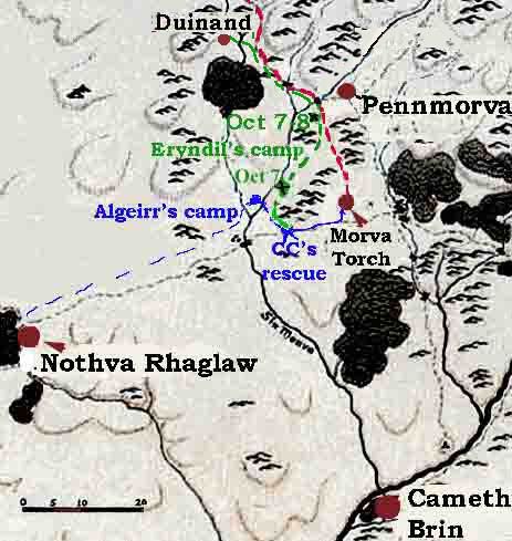 Eryndil's father's Thaneshold 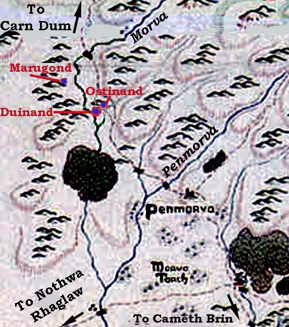 |
|
|
|
Post by Gordis on Jan 5, 2007 20:15:50 GMT
Cameth Brin, the Capitol of Rhudaur. 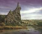 The Mountain Castle of Cameth Brin is situated on the Eastern Bank of the Mitheithel (Hoarwell). The river is wide and very swift; there is no bridge. From the MERP module: The ominous shadow of Cameth Brin, the "Twisted Hill," looms above the oaks and elms of the Trollshaws in central Rhudaur. Cameth Brin rises 830 feet above the only vale in all the Trollshaws that might otherwise be called fair. Its base is a steep but natural hill, but from this foundation erupts a tortured outcropping of naked black granite that leans impossibly far over the southern face. It looks as if a sparrow's sneeze would send the craggy top tumbling down upon the town Tanoth Brin and the valley below. But rest assured - Cameth Brin will endure far worse than sneezes. *** Cameth Brin is a castle - a big one, housing the nobles, their servants and lots of soldiers. Also it has its own smithies, bakeries etc. - So it is like a town as well. Tanoth Brin is a small town just below the steep hill where Camreth Brin stays. I think it has walls, but normally, when an army approaches, it is abandoned, all the population going to the Castle. The population is mostly peasants, merchants and artisans. |
|
|
|
Post by Gordis on Jan 5, 2007 20:22:59 GMT
|
|
|
|
Post by Gordis on Jan 5, 2007 20:23:57 GMT
|
|
|
|
Post by Gordis on Feb 11, 2007 21:18:31 GMT
Here ia a little map I made depicting the events of Nov 1-5 Gimilbeth's journey is in red, the dwarves' way is in green and the orcs's movements are in blue. 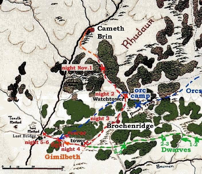 I gather Gimilbeth will try to stay for the nights in different watchtowers, not just camping in the wild. I guess the ambush will be on the Great Road not far from the Last Bridge. What do you think? |
|
|
|
Post by Witch-king of Angmar on Feb 11, 2007 23:36:48 GMT
Gordis, this map is going to be a real help. It will make everything much clearer.
|
|
|
|
Post by Gordis on Mar 24, 2007 14:08:42 GMT
Agannalo's Journey North 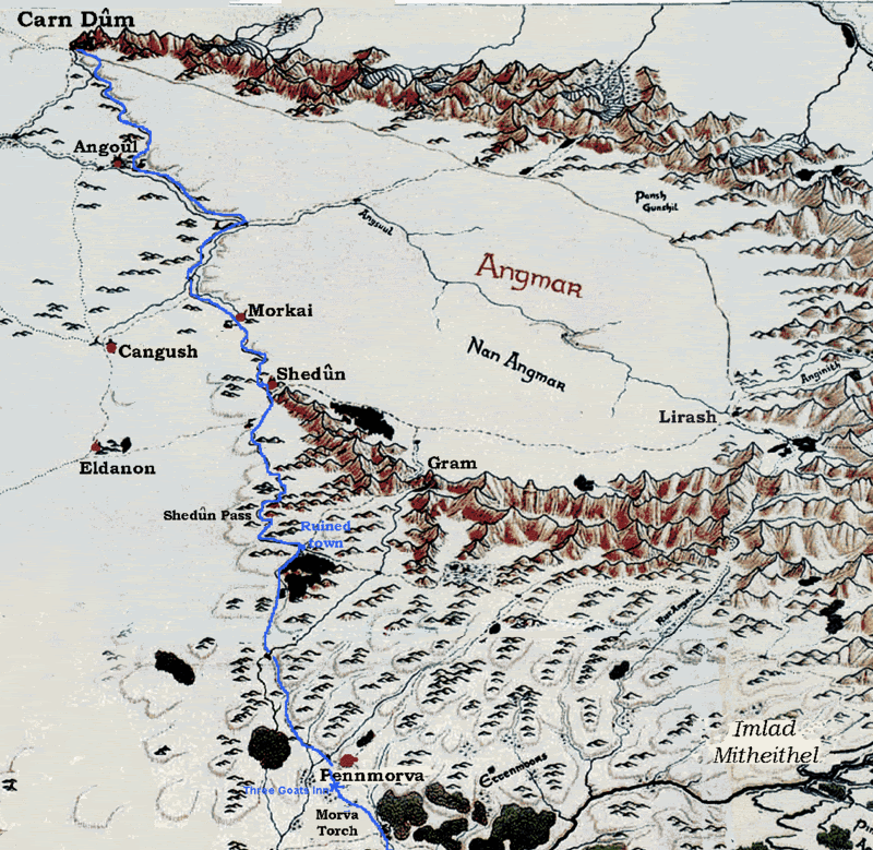 |
|
|
|
Post by Valandil on Apr 7, 2007 1:56:32 GMT
|
|
|
|
Post by Gordis on Apr 7, 2007 7:37:37 GMT
Oh it is quite interesting. Only it is difficult to follow with its small size and fast changing. Anyway, my maps are better ;D. (If I say so myself)  1 Angmar should be on both sides of the Misties. 2. I have never heard that Angmar had annexed Cardolan as far as Tharbad. 3. Eryn Vorn was hardly in Cardolan - I guess it belonged to Lindon. That was all I was able to glean in 2 minutes. But then again there is this map when Angmar becomes small again before growing really BIG. I guess this one corresponds to 1409-1974 or something. But I don't think that Rhudaur has ever become free again as shown on this map, even when Angmar was "subdued" for a time after 1409. Thoughts? |
|